Class Name: Spatial Index Related Geometry
Subclasses
This DRM class is concrete and has no subclasses.
Definition
An instance of this DRM class specifies a spatially indexed related
aggregation representing a collection of
<Geometry Hierarchy> components in which each
<Geometry Hierarchy> component represents a different tile
within this aggregation. The <Spatial Index Data> link object
corresponding to each <Geometry Hierarchy> component
indicates which tile it represents.
Primary Page in DRM Diagram:
Secondary Pages in DRM Diagram:
This class appears on only one page of the DRM class diagram.
Example
Consider a <Spatial Index Related Geometry> instance with
row_count = 1,
column_count = 4,
row_width =
1000 metres,
column_width =
1000 metres. For simplicity,
each of the four branches of the
<Spatial Index Related Geometry>
instance in this example is a
<Union Of Primitive Geometry>
instance as depicted in Figure 62.
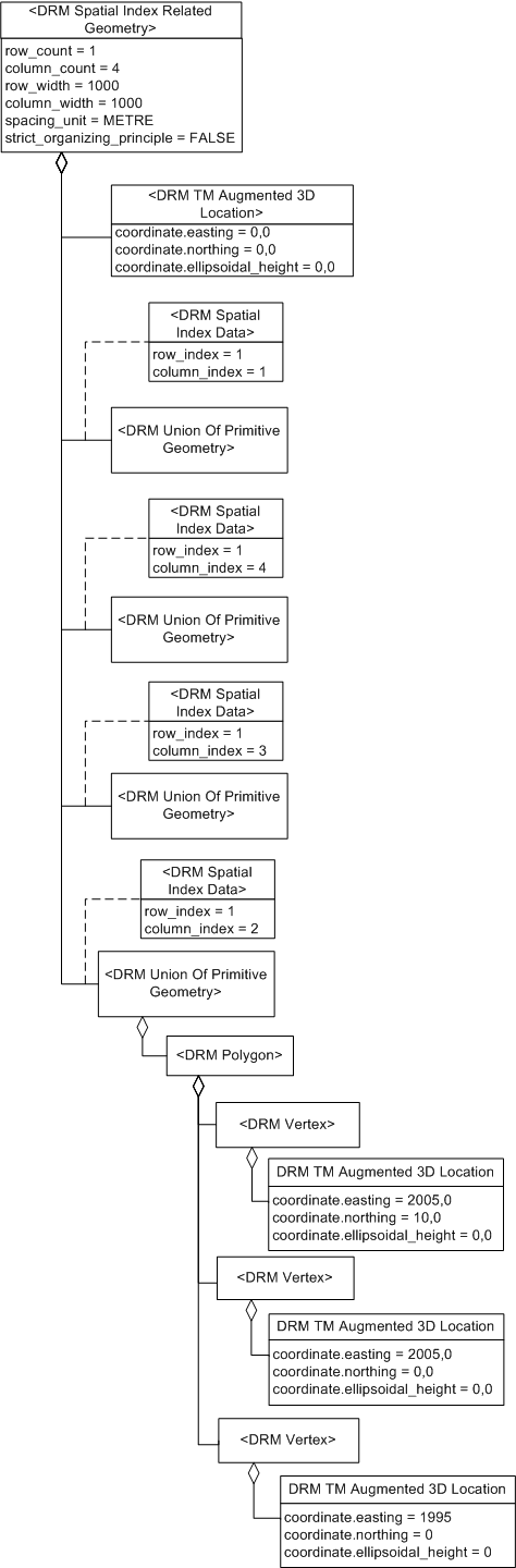
Figure 62 — <DRM Spatial Index Related Geometry> example
Since the origin of the collection (its lower left corner, the
<TM Augmented 3D Location> component)
is (0, 0, 0), the coverages of the branches are:
- from (0, 0) to (1000, 1000)
- from (1000, 0) to (2000, 1000)
- from (2000, 0) to (3000, 1000)
- from (3000, 0) to (4000, 1000)
NOTE 1
A <Spatial Index Related Geometry>
instance does not specify the range of z/height/elevation values.
Consider a triangular <Polygon> instance in branch #2
of this aggregation, with <Vertex> components having
<Location> instances
(1995, 0, 0), (2005, 0, 0) (2005, 10, 0).
Since this <Polygon> instance crosses the boundary
between branch #2 and branch #3, this
<Spatial Index Related Geometry> instance's
strict_organizing_principle
is set to SE_FALSE.
Consider an <Environment Root> instance representing a
terrain surface that is a mix of grids and polygons,
organized by spatial indexing into nine cells as depicted in
Figure 63.
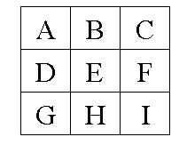
Figure 63 — <DRM Spatial Index Related Geometry> spatial indexing
All cells except H are grids (represented in
the DRM as <Property Grid> instances) captured at one
level of detail. Cell H consists of
<Polygon> instances as depicted in
Figure 64.
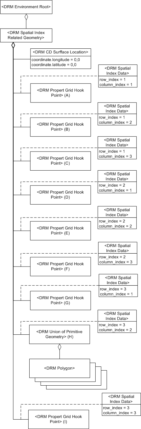
Figure 64 — <DRM Spatial Index Related Geometry> grid and polygon example
NOTE 2
The components of the <Spatial Index Related Geometry>
instance are not ordered; the <Spatial Index Data>
link objects are used to identify the individual tiles.
FAQs
-
What is the purpose of this class?
This class allows
<Geometry Representation> instances
to be organized (tiled) according to some spatial index.
-
Consider a data provider whose data consists of
terrain <Polygon> instances that are tiled along
the lines of a grid, but in which some <Polygon>
instances cross over tile boundaries. Can these
<Polygon> instances be organized with a
<Spatial Index Related Geometry>
instance?
Yes. In such a case, the
strict_organizing_principle
field of the <Spatial Index Related Geometry>
instance is set to
SE_FALSE to indicate
that the indexing is not strictly followed (see examples).
Each tile of the spatial index is represented by a
<Geometry Hierarchy> component of S.
-
Where is the origin of the spatial index?
The required <Location> component of a
<Spatial Index Related Geometry>
instance specifies the origin of the spatial index, which is its lower left
corner.
Constraints
Associated to (one-way) (inherited)
Associated by (one-way) (inherited)
Composed of (two-way) (inherited)
Composed of (two-way)
Composed of (two-way metadata) (inherited)
Component of (two-way) (inherited)
- zero or more <Alternate Hierarchy Related Geometry> instances, each through the use of a <Hierarchy Data> link object
- zero or more <Animation Related Geometry> instances
- zero or more <Classification Related Geometry> instances, each through the use of a <Classification Data> link object
- zero or one <Environment Root> instance
- zero or one <Geometry Model> instance
- zero or more <LOD Related Geometry> instances, each through the use of a <Base LOD Data> link object
- zero or more <Octant Related Geometry> instances, each through the use of an <Octant Data> link object
- zero or more <Perimeter Related Geometry> instances, each through the use of a <Perimeter Data> link object
- zero or more <Quadrant Related Geometry> instances, each through the use of a <Quadrant Data> link object
- zero or more <Separating Plane Relations> instances, each through the use of a <Separating Plane Data> link object
- zero or more <Spatial Index Related Geometry> instances, each through the use of a <Spatial Index Data> link object
- zero or more <State Related Geometry> instances, each through the use of a <State Data> link object
- zero or more <Time Related Geometry> instances, each through the use of a <Time Constraints Data> link object
- zero or more <Union Of Geometry Hierarchy> instances
Notes
Associated to Notes
An association between a
<Feature Representation>
instance and a
<Geometry Hierarchy> instance
indicates that the environmental object(s) that they
represent have the semantic relationship indicated by
the <Base Association Data>
link object on the association relationship.
An association between two
<Geometry Hierarchy> instances
indicates that the environmental object(s) that they
represent have the semantic relationship indicated by
the <Base Association Data>
link object on the association relationship.
Associated from Notes
An association between a
<Feature Representation>
instance and a
<Geometry Hierarchy> instance
indicates that the environmental object(s) that they
represent have the semantic relationship indicated by
the <Base Association Data>
link object on the association relationship.
An association between two
<Geometry Hierarchy> instances
indicates that the environmental object(s) that they
represent have the semantic relationship indicated by
the <Base Association Data>
link object on the association relationship.
An association from a
<Hierarchy Summary Item>
instance to a <Geometry Hierarchy>
instance indicates that the
<Hierarchy Summary Item> instance
summarizes that <Geometry Hierarchy>
instance.
An association from a
<Reference Surface> instance to a
<Geometry Hierarchy> instance indicates
that the <Geometry Hierarchy>
instance organizes the geometric objects that specify
the reference surface geometry of the
<Reference Surface> instance.
Composed of Notes
In the case where multiple
<Collision Volume> components are
specified for the
<Aggregate Geometry> instance,
the union
of the volumes thus specified is used in collision detection.
An <Aggregate Geometry> instance can have
an <LSR Transformation> component only when the
<Aggregate Geometry> instance is within
the scope of an LSR 3D SRF.
The <Location> component is the origin of the collection,
which is the lower left corner.
Fields Notes
If the value of the
unique_descendants
field is SE_TRUE, each
descendant of this aggregation, that is, each
<Geometry Representation>
instance that exists in the component tree
rooted at the <Aggregate Geometry>
instance shall be unique, in the
sense that it shall appear in only one branch
of this aggregation.
If unique_descendants
is SE_FALSE, at least one
<Geometry Representation> instance
appears in more than one branch of the aggregation.
If the value of the
strict_organizing_principle
field is SE_TRUE, each
branch of this aggregation
strictly complies with the organizing principle for its
particular subclass. If this value is
SE_FALSE, at least
one branch does not strictly comply with the given
organizing principle. See the organizing principle constraint
for each specific subclass for details.
If the value of the sparse field
is SE_FALSE,
all column and row entries are present;
otherwise one or more entries are not present.
The column_count field
specifies the number of cells along the primary axis.
The row_count field
specifies the number of cells along the secondary axis.
The column_width field specifies
the length of a cell in the given unit along the primary axis.
The row_width field specifies
the length of a cell in the given unit along the secondary axis.
The spacing_unit field
specifies the unit of measurement for
column_width and
row_width.
Prev: Spatial Index Related Features.
Next: Spatial Index Related Geometry Topology.
Up:Index.